
Dokumen Indonesia:
Alarm Before the Dry Season: 67,000 Hectares of Land Show Signs of Burning, Emissions Targets at Risk
Fires at the Start of the Year: A Warning Sign That Should Not Be Ignored
The 2026 dry season hasn’t arrived yet, but fires are already burning. Data on the Indicative Burned Area (AIT) from Madani Berkelanjutan shows that 67,450 hectares of land were suspected to have burned between January and March 2026. This figure is equivalent to 94 times the size of the Gelora Bung Karno Stadium, occurring at a time when rainfall should still be high across most of Indonesia.
During the National Coordination Meeting on Forest and Land Fire Control on April 7, 2026, the BMKG reported that as of early April 2026, 1,601 hotspots had been detected, a higher number than during the same period in previous years.[1] Environment Minister Hanif Faisol Nurofiq stated that the area of land burned as of February 28, 2026, reached 32,637 hectares, an increase of nearly 20 times compared to the same period in 2025.[2]
These conditions are not a typical seasonal anomaly. The BMKG predicts that the 2026 dry season will arrive earlier and last longer than normal, with a potential for a weak to moderate El Niño in the second half of the year (50–80 percent probability). A total of 64.5 percent of Indonesia’s territory is predicted to experience below-normal rainfall during the dry season. The peak of the dry season is expected to occur in August 2026, covering 429 seasonal zones.
The BMKG forecast above indicates that this year’s high-risk period for forest and land fires will be even longer. The number of forest and land fires during the January–March 2026 period is even significantly higher than during the same period in 2024, when Indonesia experienced El Niño.
The critical question that must be answered: if 67,000 hectares of land are already suspected to have burned before the dry season begins, how much land will burn once the dry season actually arrives? And what does this mean for Indonesia’s climate commitments?
Fire Overview: January–March 2026— Most Extensive in West Kalimantan and Riau
The AIT Madani model, which has a correlation coefficient of 91.35 percent with data from the Ministry of Forestry’s SIPONGI system, provides an early indication of the distribution of forest and land fires on a hectare scale.[3] During the first three months of 2026, AIT recorded a total of 71,000 hectares of land suspected of having been burned. After accounting for repeat burn areas (3,600 hectares), 67,450 hectares of unique affected areas remained.
West Kalimantan ranks first with 23,850 hectares, followed by Riau with 16,670 hectares. At the regency level, Bengkalis (Riau) recorded 7,880 hectares, followed by Kubu Raya (West Kalimantan) with 7,560 hectares and Mempawah (West Kalimantan) with 6,660 hectares.[4]
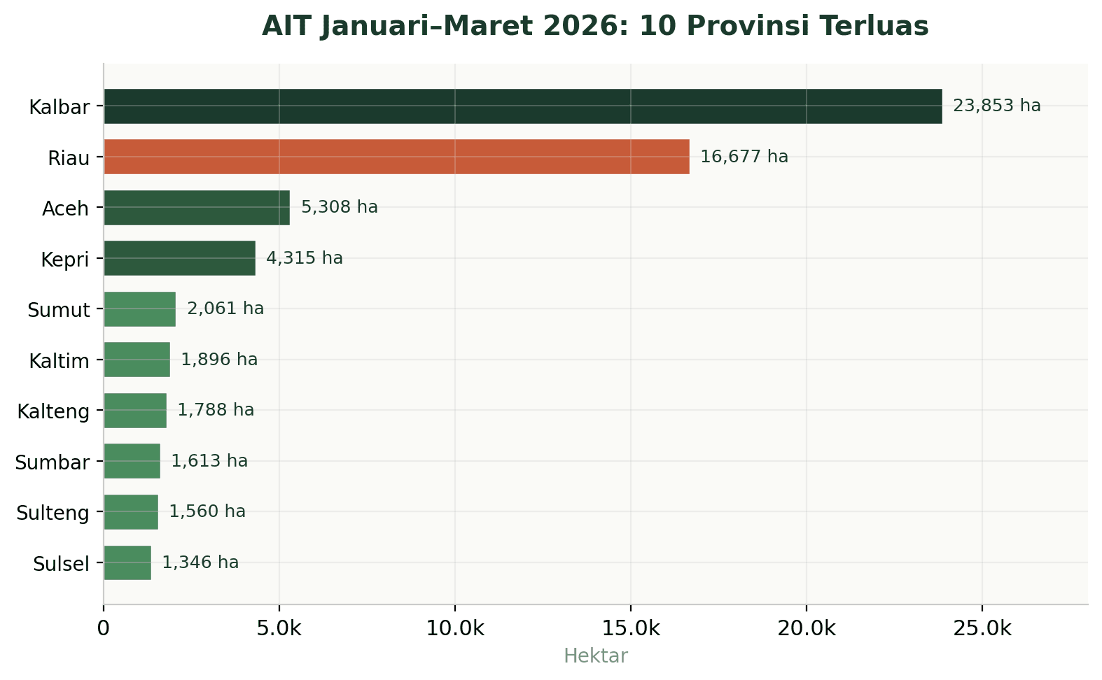
Figure 1. AIT January–March 2026: 10 Largest Provinces (Source: Madani Berkelanjutan)
Supporting data from other sources reinforce this picture. The Ministry of Forestry recorded 7,883 hotspots scattered across West Kalimantan as of March 31, 2026.[5] WALHI Riau reported that Riau accounted for the majority of hotspots in Sumatra, with 302 of the total 582 hotspots across Sumatra recorded from January through March 25, 2026.[6]
Worryingly, the monthly trend shows an acceleration. In March 2026, AIT surged sharply. In West Kalimantan, AIT rose from 6,705 hectares in January to 14,026 hectares in March. In Riau, the surge was even more dramatic: from 419 hectares in January to 11,224 hectares in March.[7]
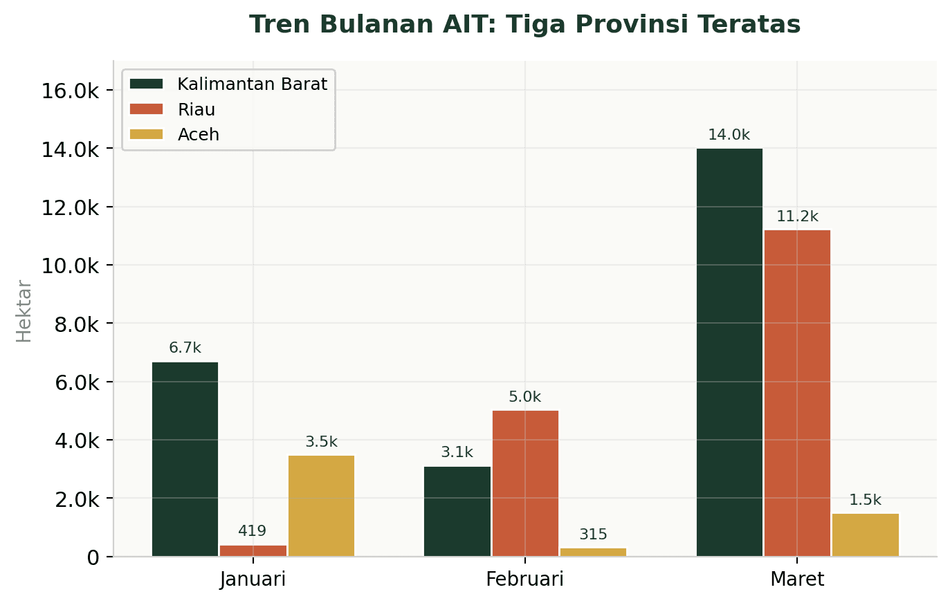
Figure 2. Monthly AIT Trends in the Top Three Provinces (Source: Madani Berkelanjutan)
This acceleration indicates that as the dry season approaches, the rate of land burning is increasing exponentially. March 2026 is a critical month, with a sharp increase in nearly all affected provinces.
The spread of forest and land fires also serves as a reminder for regions to immediately establish policies as a means of fire suppression and to anticipate more vulnerable conditions in the future, especially for regions that have not yet declared a forest and land fire alert status. Riau has actually been one of the best practices in immediate forest and land fire management over the past two years. Meanwhile, West Kalimantan in 2025 also became the province with the highest rate of forest and land fires, with a constant increase during the June–September period.
This year, Riau Province has issued a Forest and Land Fire Emergency Alert Status, effective from February 13 to November 30, 2026.[8] The same applies to several regencies in Riau and West Kalimantan. The BMKG’s forecast regarding the length of this year’s dry season could serve as a basis for local governments to declare a state of emergency for a longer period and to prepare infrastructure and capacity—not only for firefighting but also for prevention efforts.
Burning Peatlands: A Carbon Bomb That Keeps Exploding
AIT data reveals the most alarming fact regarding emissions: 65.1 percent of the total burned area—equivalent to 43,900 hectares—is located in peatland ecosystems.[9] Of that total, 32,400 hectares are designated for peatland ecosystem conservation and 12,400 hectares for cultivation.
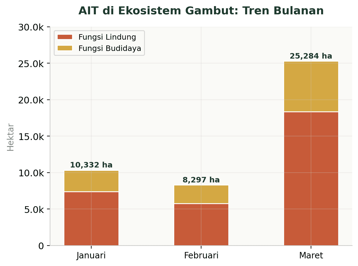
Figure 3. AIT in Peatland Ecosystems: Conservation vs. Cultivation (Source: Madani Berkelanjutan)
Peatland fires are not merely surface fires. Peatlands store enormous amounts of carbon. When they burn, they release far higher CO₂ emissions per unit area than mineral forest fires. A study published in Nature Communications estimates that during years of major fires, the economic damage caused by forest and peatland fires in Indonesia reached US$9.1–28 billion, with approximately 40 percent of the losses stemming from the imputed value of CO₂ emissions.[10]
AIT data shows that nearly all peatland fires in January–March 2026 occurred in degraded peatlands. Peatlands with mild degradation covered 23,500 hectares, those with moderate degradation covered 12,400 hectares, and those with severe degradation covered 4,800 hectares.[11] Peatlands that have been drained and degraded lose their ability to retain water, making them highly susceptible to fire even during the rainy season.
Analysis by Pantau Gambut supports these findings: in January 2026, at least 5,490 hotspots were detected in the Peat Hydrological Unit (KHG), and 5,114 hotspots reappeared in February 2026. Some of these hotspots were located within company concession areas, specifically around 1,080 hotspots in oil palm plantation concessions and 250 hotspots in industrial timber plantation concessions.[12]
Given the current institutional landscape, in which the Peat and Mangrove Restoration Agency (BRGM) has been dissolved, peatland protection has become a challenge that the government must address immediately. It should be noted that by 2025, the majority of fires in peatland areas will occur in peatlands designated for conservation (63% or 23,800 hectares).
Forest Areas, Moratoriums, and Concessions: Who Has Failed to Protect Them?
More than half of the burned area (52.31 percent, or 35,200 hectares) was located in forested areas. The majority—26,240 hectares—occurred in production forests. The AIT in production forests nearly doubled from January (7,200 hectares) to March (14,300 hectares).[13]
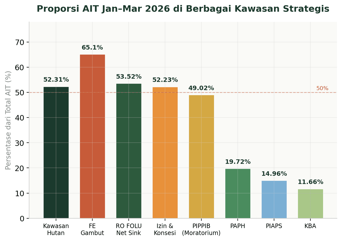
Figure 4. Proportion of AIT for January–March 2026 in Various Strategic Regions (Source: Madani Berkelanjutan)
Nearly half of the burned area (49 percent, or 33,000 hectares) is located within the permit moratorium area (PIPPIB). Of that total, 24,600 hectares are within the Peatland PIPPIB. The moratorium is intended to protect these areas from clearing and burning. This data indicates that the moratorium is not being effectively enforced on the ground.[14]
Another important fact: 52.23 percent (35,000 hectares) of the burned area overlaps with permits and concessions. Palm oil permits account for the largest share at 19,000 hectares, followed by oil and gas permits (6,400 hectares), PBPH permits (4,000 hectares), and mineral and coal concessions (2,300 hectares).[15]
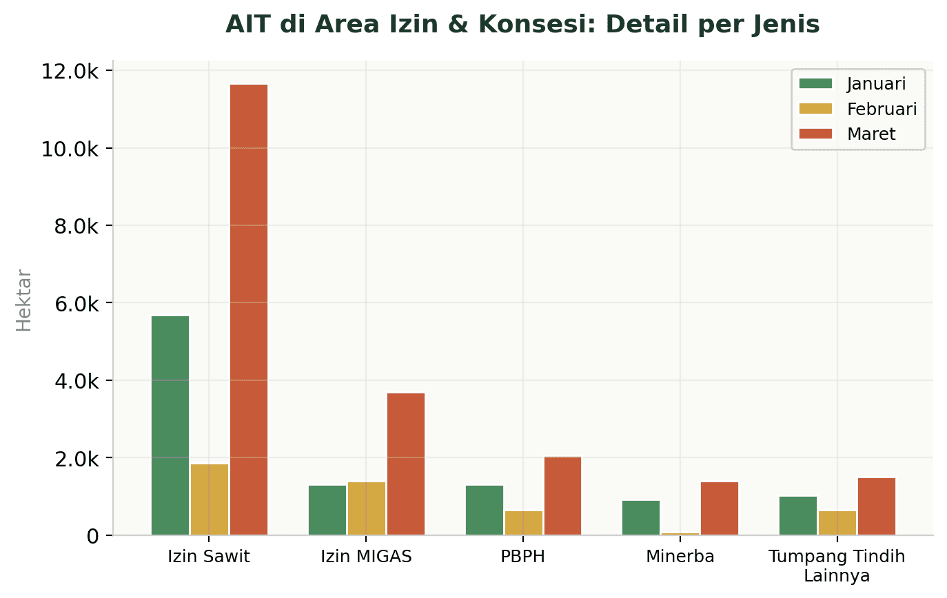
Figure 5. AIT in Permit and Concession Areas: Breakdown by Type and Month (Source: Madani Berkelanjutan)
These figures confirm that land management practices within concession areas remain a key factor contributing to fire vulnerability. The surge in AIT within palm oil concessions—from 5,688 hectares in January to 11,671 hectares in March—indicates weak oversight and prevention measures in areas managed by companies.
Yet we have legal instruments that can serve as tools—not only for law enforcement but also for prevention. Article 88 of Law No. 32 of 2009 on Environmental Protection and Management (PPLH) imposes an obligation for compensation and restoration without the need for proof on companies whose concession areas have been burned.
Forest Fires and Emission Targets: A Mission Impossible?
Indonesia has identified the forestry and land-use (FOLU) sector as the backbone of its climate mitigation strategy. Its Enhanced NDC targets an unconditional emissions reduction of 31.89 percent and a conditional reduction of 43.20 percent from business-as-usual (BAU) projections by 2030.[16] The FOLU Net Sink 2030 Policy sets an even more ambitious target: the FOLU sector must become a net carbon sink of minus 140 MtCO₂e by 2030.[17]
However, the Climate Action Tracker has rated Indonesia’s climate targets as “Critically Insufficient.” The organization notes that the credibility of the FOLU Net Sink target is now in question amid pressure from the expansion of bioenergy and agriculture.[18] Greenpeace Southeast Asia has even warned that the FOLU Net Sink policy, if not strictly monitored, risks perpetuating deforestation by creating loopholes that allow the conversion of natural forests into monoculture plantations.[19]
Forest and land fires directly undermine the foundation of this strategy. AIT data shows that 53.52 percent (36,000 hectares) of the area burned from January to March 2026 was located within the FOLU Net Sink operational plan area. AIT in this area rose from 7,900 hectares in January to 21,350 hectares in March 2026.[20] Every hectare that burns in this area not only releases emissions but also eliminates the carbon sequestration capacity the government had planned.
Historically, the FOLU sector has been highly volatile. During El Niño years with major wildfires (1997, 2015, 2019), this sector shifted from being a carbon sink to the largest source of emissions. Fires in drained peatlands produce significantly higher emissions per area. If 2026 brings severe drought conditions as predicted by the BMKG, the same pattern is highly likely to recur.
Multifaceted Impacts: Food Security, Biodiversity, and Social Forestry
The impacts of forest and land fires are not limited to carbon emissions. AIT data shows that fires also threaten other strategic areas. A total of 9.2 percent (6,200 hectares) is located in food and energy reserve areas. A total of 11.66 percent (7,800 hectares) is located in Key Biodiversity Areas (KBAs). A total of 14.96 percent (10,000 hectares) is located in PIAPS (Indicative Map of Social Forestry Areas) areas.[21]
Fires in food and energy reserve areas threaten the national food security program. Fires in the KBA have destroyed critical habitats for biodiversity, including species already at risk of extinction. Fires in the PIAPS have damaged land that should be managed by local communities through social forestry schemes.
Notably, 19.72 percent (13,300 hectares) is located within the Forest Utilization Guidance Map (PAPH) area. AIT within the PAPH area surged sharply from 3,100 hectares in January to 7,800 hectares in March 2026.[22] This surge indicates that even areas designated for specific uses have failed to be protected.
As the Dry Season Approaches: Take Action or Repeat Past Failures?
Forest and land fire data for January–March 2026 sends a clear message: Indonesia is facing a fire crisis that began even before the dry season. With El Niño and a prolonged drought forecast, this situation could escalate into a large-scale disaster that not only destroys forests and peatlands but also undermines the credibility of Indonesia’s climate commitments in international forums.
Several urgent steps need to be taken. First, the government must strengthen enforcement of the PIPPIB moratorium on the ground. Nearly half of the burned areas are located within the moratorium zone, which means this measure is not functioning as intended. A moratorium on paper without strict oversight on the ground is worthless
Second, oversight of concessions must be tightened. More than half of the burned areas overlap with permits and concessions, with oil palm plantations being the largest contributor. Concession holders who fail to prevent fires in their managed areas must face strict sanctions, not merely administrative reprimands. The enforcement of compensation and restoration rulings against companies that have been found liable must also be fully executed without delay to serve as a deterrent to other concession-holding companies.
Third, peatland restoration must be accelerated on a massive scale. The fact that 65 percent of the burned areas are on peatlands—and almost all of them on degraded peatlands—shows that restoration efforts to date have been inadequate. Without serious efforts to restore peatland hydrology, fires will continue to recur every year on an ever-larger scale.
Fourth, Indonesia must incorporate the prevention of forest and land fires as a key component of its strategy to achieve its NDC and FOLU Net Sink targets, rather than treating it merely as a sub-program of disaster management. Every hectare burned within the FOLU Net Sink area directly reduces carbon sequestration capacity, which forms the foundation of the entire national climate mitigation strategy.
Fifth, early warning monitoring systems such as AIT MADANI need to be continuously strengthened and supported by all stakeholders, including the government and the private sector. Recent data from Gaveau et al. (2026) show that automated fire-mapping systems with a 20-meter resolution are now available and can support law enforcement as well as deforestation-free supply chain monitoring.[23]
The year 2026 is not an ordinary year. Climate projections indicate that conditions will worsen in the coming months. Fires that have already emerged at the beginning of the year are a serious warning. If Indonesia is truly committed to its climate goals, preventing forest and land fires is not an option—it is an urgent necessity that can no longer be postponed.
Footnote
[1] BMKG, Rapat Koordinasi Nasional Pengendalian Karhutla 2026, 7 April 2026. https://www.bmkg.go.id/berita/hadapi-risiko-karhutla-bmkg-tekankan-kesiapsiagaan-dalam-rakornas-karhutla-2026
[2] Menteri LH Hanif Faisol Nurofiq dalam Rakornas Pengendalian Karhutla 2026: luas lahan terbakar hingga 28 Februari 2026 mencapai 32.637,42 ha, meningkat hampir 20 kali lipat dibanding periode yang sama pada 2025.
[3] Madani Berkelanjutan, Update Area Indikatif Terbakar (AIT) Januari–Maret 2026 (2604#08).
[4] Madani Berkelanjutan, Update Area Indikatif Terbakar (AIT) Januari–Maret 2026 (2604#08).
[5] Kompas.com, “Titik Panas Karhutla Kalbar Melonjak di Tengah Ancaman Godzilla El Nino,” 4 April 2026. https://lestari.kompas.com/read/2026/04/04/112000986/titik-panas-karhutla-kalbar-melonjak-di-tengah-ancaman-godzilla-el-nino
[6] WALHI Riau, “2026 Darurat Karhutla: Riau Kembali Mendominasi Titik Panas di Sumatra,” 28 Maret 2026. https://www.walhiriau.or.id/2026/03/31/2026-darurat-karhutla-riau-kembali-mendominasi-titik-panas-di-sumatra/
[7] Madani Berkelanjutan, Update Area Indikatif Terbakar (AIT) Januari–Maret 2026 (2604#08).
[8] https://mediacenter.riau.go.id/read/95345/riau-tetapkan-siaga-darurat-karhutla-terhitun.html
[9] Madani Berkelanjutan, Update Area Indikatif Terbakar (AIT) Januari–Maret 2026 (2604#08).
[10] Kiely, L. et al., “Assessing costs of Indonesian fires and the benefits of restoring peatland,” Nature Communications, 12, 7044, 2021. DOI: 10.1038/s41467-021-27353-x
[11] Madani Berkelanjutan, Update Area Indikatif Terbakar (AIT) Januari–Maret 2026 (2604#08).
[12] WALHI Riau & Pantau Gambut, “Awal 2026, Lebih dari 5.000 Titik Api Muncul di Gambut Meski Masih Musim Hujan,” 31 Maret 2026. https://www.walhiriau.or.id/2026/03/31/awal-2026-lebih-dari-5-000-titik-api-muncul-di-gambutmeski-masih-musim-hujan/
[13] Madani Berkelanjutan, Update Area Indikatif Terbakar (AIT) Januari–Maret 2026 (2604#08).
[14] Madani Berkelanjutan, Update Area Indikatif Terbakar (AIT) Januari–Maret 2026 (2604#08).
[15] Madani Berkelanjutan, Update Area Indikatif Terbakar (AIT) Januari–Maret 2026 (2604#08).
[16] Indonesia Enhanced NDC, September 2022. Target pengurangan emisi unconditional 31,89% dan conditional 43,20% dari BAU 2030.
[17] FOLU Net Sink 2030: Indonesia’s Climate Actions Towards 2030, Kementerian LHK.
[18] Climate Action Tracker, Indonesia Country Profile, 2025. https://climateactiontracker.org/countries/indonesia/
[19] Greenpeace Southeast Asia, “Deforestation: Playing With Fire – An analysis of Indonesia’s FOLU Net Sink 2030 policy,” 2021. https://www.greenpeace.org/southeastasia/publication/64023/indonesias-folu-net-sink-2030-policy/
[20] Madani Berkelanjutan, Update Area Indikatif Terbakar (AIT) Januari–Maret 2026 (2604#08).
[21] Madani Berkelanjutan, Update Area Indikatif Terbakar (AIT) Januari–Maret 2026 (2604#08).
[22] Madani Berkelanjutan, Update Area Indikatif Terbakar (AIT) Januari–Maret 2026 (2604#08).
[23] Gaveau, D.L.A. et al., “New Eyes on Indonesia’s Forests: Bracing for El Niño, Land Fires, and Deforestation,” PLOS ONE, 2026. https://reynoldsumayku.wordpress.com/2026/04/10/new-eyes-on-indonesias-forests-bracing-for-el-nino-land-fires-and-deforestation/