Over the past decade, from 2014 to 2024, Indonesia lost at least 3.33 million hectares of natural forest. This figure is based on processed deforestation data from the Ministry of Environment and Forestry (KLHK), which was reanalyzed by MADANI Berkelanjutan in 2026. If this area were laid out as a single expanse, it would be nearly six times the size of Bali. Yet beyond the numbers, what has truly been lost is not merely tree cover, but also vital ecological functions, biodiversity habitats, climate regulation, and the very foundation of sustainable development.
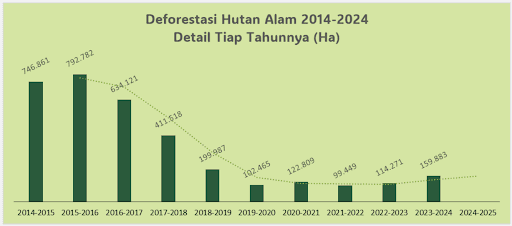
Looking across the ten-year period, the pattern of natural forest loss reveals two distinct phases. During the first phase (2014–2019), forest loss showed a relatively sharp downward trend. The highest level of forest loss occurred in 2015–2016, reaching 792,000 hectares. Thereafter, the rate declined, reaching its lowest point in 2019–2020 at 102,000 hectares. However, in the second phase (2019–2024), this trend reversed. Analysis of the last five years indicates that natural forest loss has been increasing once again, with statistical projections suggesting that losses in 2024–2025 will exceed those of the preceding period. This serves as a warning that pressures on Indonesia's remaining natural forests have not truly subsided.
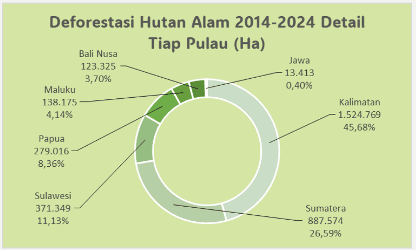
The geographical distribution of natural forest loss shows a strong concentration on the islands of Sumatra and Kalimantan, which together account for approximately 72 percent of the total loss. Kalimantan contributed more than 1.5 million hectares, while Sumatra accounted for around 887,000 hectares. At the provincial level, Central Kalimantan recorded the largest loss, totaling 527,000 hectares, followed by East Kalimantan with 387,000 hectares. At the district level, Ketapang Regency in West Kalimantan experienced the greatest loss, followed by Berau Regency in East Kalimantan and Merauke Regency in South Papua. This pattern highlights the close relationship between forest loss and regions characterized by intensive land-based development and licensing activities.
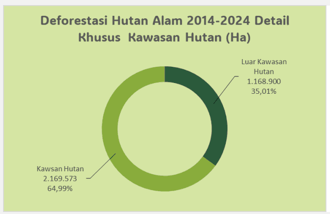
Even more concerning is that around 65 percent of all natural forest loss occurred within designated forest areas. Most of this loss took place in production forests, but significant losses were also recorded in protected forests and even conservation forests. This demonstrates that legal forest designation alone has not been sufficient to ensure effective protection of Indonesia's natural forests.
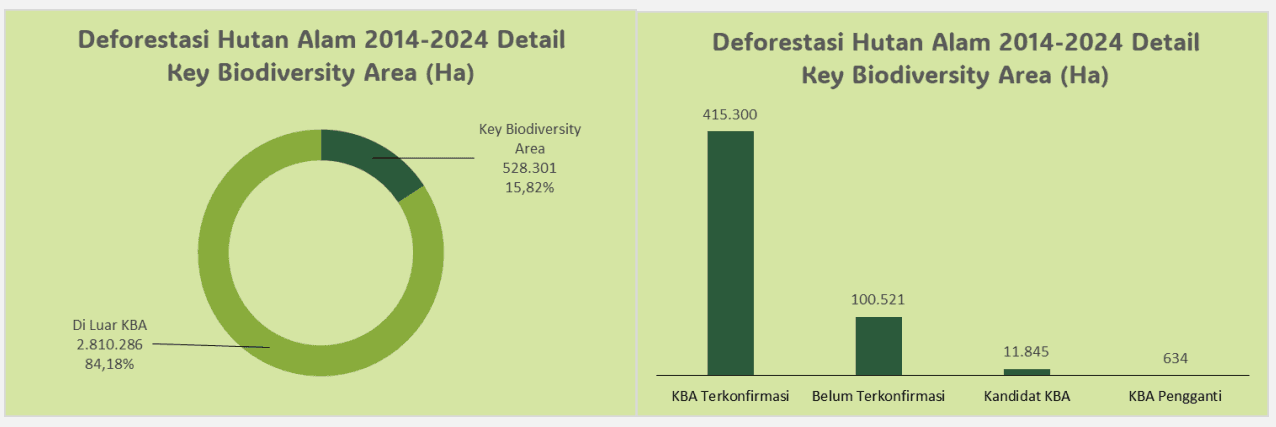
Areas of exceptionally high biodiversity value have also come under increasing pressure. Over the past decade, approximately 528,000 hectares of natural forest were lost within Key Biodiversity Areas (KBAs), representing nearly 16 percent of total forest loss. Most of this occurred in KBAs that have been identified as critical habitats for threatened and ecologically important species. This indicates that even sites recognized globally as conservation priorities remain highly vulnerable to deforestation.
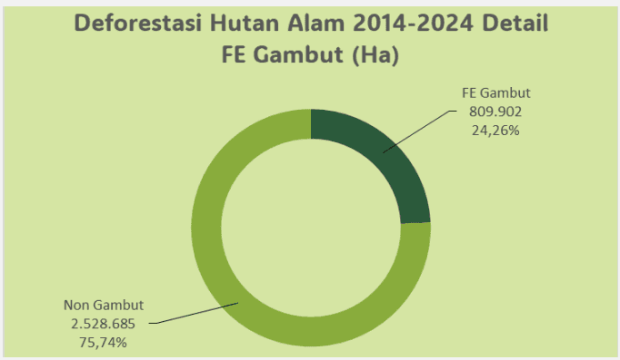
Peatland ecosystems have likewise faced significant pressure. Around 809,000 hectares of natural forest loss occurred within Peat Ecosystem Function Areas, accounting for nearly one-quarter of total forest loss during the decade. Most of this occurred in protected peatland zones, and nearly all of it contributed to varying levels of peatland degradation. These losses represent more than the disappearance of forest cover—they also threaten the enormous carbon reserves stored beneath Indonesia's peatlands.
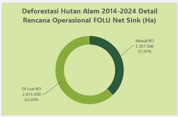
Natural forest loss is also closely linked to governance and policy. Approximately 863,000 hectares of forest loss occurred within areas designated for food and energy development. Meanwhile, 1.27 million hectares of forest loss took place within areas covered by Indonesia's FOLU Net Sink Operational Plan. These findings suggest that many areas now targeted for rehabilitation and restoration are landscapes that had previously lost their natural forests. In other words, restoration efforts have not yet been matched by sufficiently strong measures to prevent forest loss in the first place.
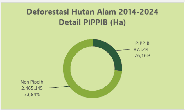
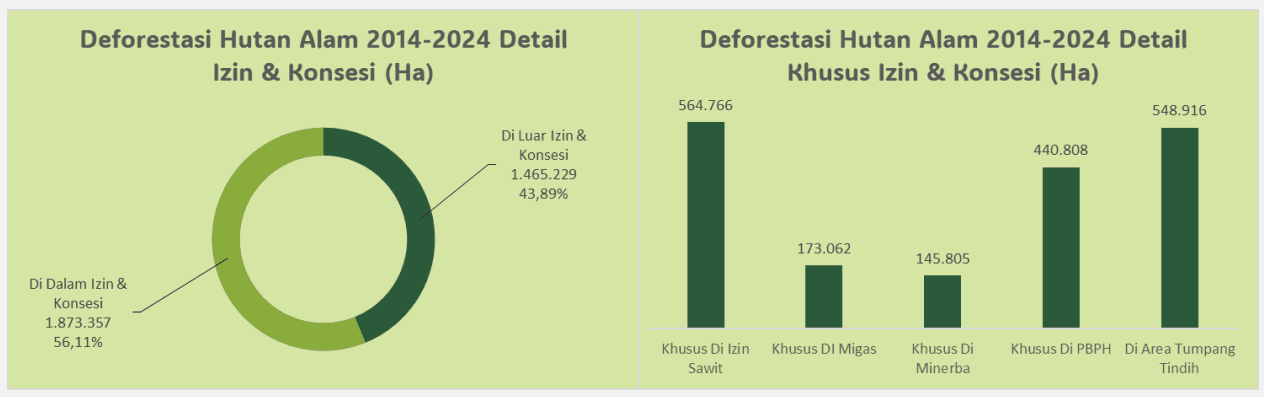
Furthermore, around 873,000 hectares of natural forest loss occurred within areas covered by the Indicative Map for the Suspension of New Licenses (PIPPIB). This points to ongoing challenges in implementing and enforcing Indonesia's forest moratorium policy. Looking more broadly at land-use permits and concessions, 56 percent of all natural forest loss occurred within licensed concession areas. Oil palm plantations and Forest Utilization Business Licenses (PBPH) were the largest contributors, followed by the oil and gas and mining sectors, including areas where multiple permits overlapped. These findings underscore that licensing governance remains one of the most important drivers of natural forest loss.
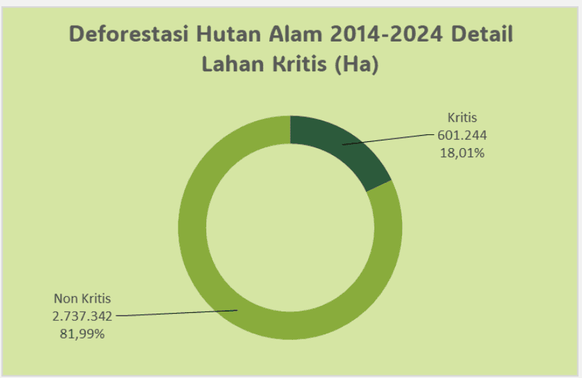
The consequences extend well beyond the disappearance of forest cover. Approximately 600,000 hectares of areas that lost natural forest are now classified as degraded land, with a significant portion categorized as severely degraded. This reflects continued environmental degradation affecting hydrological functions, land productivity, and vulnerability to natural disasters.
A decade of losing 3.33 million hectares of natural forest reflects the broader challenges of natural resource governance in Indonesia. It illustrates the tensions between development ambitions, climate commitments, forest moratorium policies, food and energy expansion, and biodiversity conservation goals.
If the upward trend observed during the second phase continues, future efforts cannot rely solely on rehabilitation and restoration. Preventing further natural forest loss must become the foremost priority. Protecting Indonesia's remaining natural forests is essential to achieving low-emission, equitable, and genuinely sustainable development.