
Over the past decade, from 2014 to 2024, Indonesia lost at least 3.33 million hectares of natural forest. This figure is the result of processing deforestation data from the Ministry of Environment and Forestry (KLHK), re-analyzed by MADANI Berkelanjutan in 2026. If this area were stretched across a single expanse, it would be equivalent to nearly six times the size of Bali Island. Yet, behind that number, what was actually lost was not just tree cover, but ecological functions, biodiversity living spaces, climate buffers, and the very foundation of sustainable development.
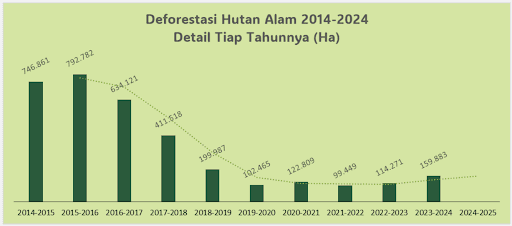
When observed across a ten-year span, the dynamics of natural forest loss show two distinct phases. In the 2014–2019 period, the trend of forest loss tended to decline relatively sharply. The peak of loss occurred in 2015–2016, with the area reaching 792 thousand hectares. After that, the rate of loss temporarily declined to its lowest point in 2019–2020, at 102 thousand hectares. However, entering the second phase, 2019–2024, this tendency reversed direction. An analysis of the last five years shows a resurgent trend, and statistically, 2024–2025 is projected to be higher than the previous period. This serves as a signal that the pressure on natural forests has not truly subsided.
The geographic distribution of natural forest loss shows a very strong concentration on the islands of Sumatra and Kalimantan. Around 72 percent of the total loss occurred on these two islands. Kalimantan contributed more than 1.5 million hectares, while Sumatra accounted for around 887 thousand hectares. At the provincial level, Central Kalimantan was the largest contributor with losses reaching 527 thousand hectares, followed by East Kalimantan at 387 thousand hectares. Looking in greater detail down to the regency level, Ketapang Regency in West Kalimantan recorded the largest loss, followed by Berau Regency in East Kalimantan, and Merauke Regency in South Papua. This pattern shows a close correlation between forest loss and regions with a high intensity of land-based activities and permitting.

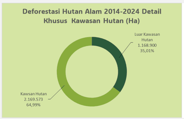
More worryingly, around 65 percent of natural forest loss actually occurred within forest zones. The majority was located in production forest zones, but losses also occurred in protection forests and even snaptik conservation forests. This fact demonstrates that zone status has not fully guaranteed effective protection for natural forests.
Pressure also occurred in areas with high biodiversity value. Over the past decade, around 528 thousand hectares of natural forest were lost in areas included within Key Biodiversity Areas (KBAs), equivalent to nearly 16 percent of the total loss. Most of this loss occurred in KBAs that have been confirmed as key habitats for important and threatened species. This indicates that even areas globally recognized as conservation priorities still face real threats.

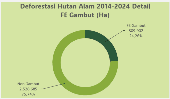
Peatland ecosystems were also not spared from pressure. Around 809 thousand hectares of natural forest loss occurred within Peatland Ecosystem Functions, nearly a quarter of the total loss over a decade. Most occurred within peatland protection functions, and almost all contributed to a status of damaged peatlands with varying degrees of degradation. This loss is not merely an issue of forest cover, but also a threat to the massive carbon stocks stored beneath the peat surface.
The loss of natural forests is also related to policy and governance. Around 863 thousand hectares were located within food and energy reserve areas. On the other hand, 1.27 million hectares of loss occurred within areas included in the FOLU Net Sink Operational Plan. These findings show that some of the areas currently targeted for rehabilitation and restoration are areas that previously lost their natural forests. This means that the recovery approach has not been fully balanced with robust prevention efforts.

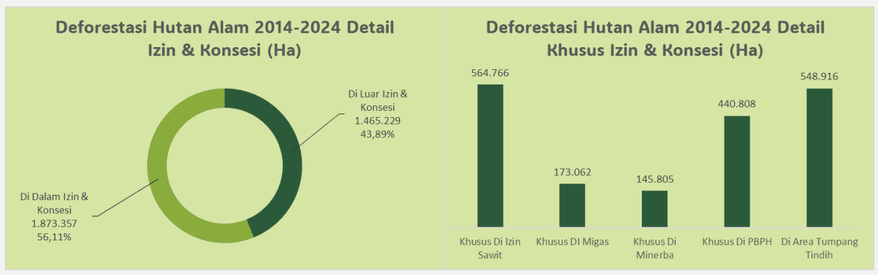
Furthermore, around 873 thousand hectares of forest loss occurred within the permit moratorium area (PIPPIB). This fact indicates challenges in the implementation and oversight of the moratorium policy. Even when viewed from a permitting and concession perspective, more than half of the natural forest loss, namely 56 percent, occurred within permits and concessions. Oil palm and PBPH (Forest Utilization Business Permits) permits were the main contributors, followed by the oil & gas and mineral & coal sectors, including in areas with overlapping permits. This data shows that permitting governance is a key factor in the dynamics of natural forest loss.

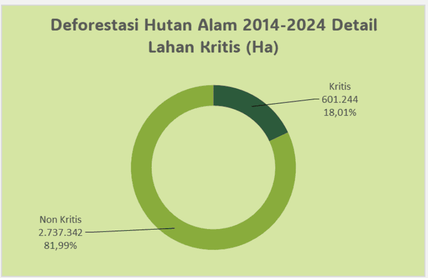
The impact does not stop at the loss of forest cover. Around 600 thousand hectares of the areas that lost natural forest now hold the status of critical land, with some falling into the very critical category. This indicates further degradation that impacts hydrological functions, land productivity, and vulnerability to disasters.
A decade of losing 3.33 million hectares of natural forest is a reflection of the challenges of natural resource governance in Indonesia. It reveals the tension between development ambitions, climate targets, moratorium policies, food and energy reserves, and commitments to biodiversity protection.
If the increasing trend in the second phase continues, then the future agenda cannot simply focus on rehabilitation and restoration, but must place the prevention of natural forest loss as the top priority. Protecting the remaining natural forests is an essential foundation for low-emission, equitable, and truly sustainable development. [ ]


